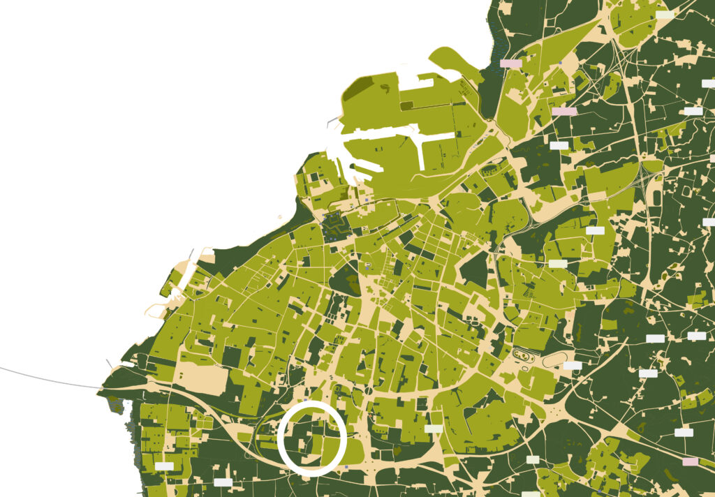
The project area is located south of Hyllie in Malmö, Sweden. In Hyllie, a new innovative neighbourhood is about to be built. The area aims to produce zero carbon and will be the first of its kind in Europe.
Hyllie Nature Axis’s primary purpose is to serve as a transitional zone between the urban and rural landscapes in the district of Hyllie, an ongoing urban development project situated on previously agricultural land in the outskirts of southwest Malmö. The planned area for the nature axis is located in the development area’s most southern part, and therefore constitutes the fringe between the urban and the rural landscape.
To the west of the project area, there is a district called Vintrie, to the south agricultural land, and to the east a small industrial area. The area slated to become the nature axis lies amidst agricultural fields. In the plan, the northern boundary of this axis will adjoin newly constructed residential areas. The current landscape is characterised by a narrow strip of greenery, featuring a ditch and a line of trees including elm, ash, oak, sycamore maple, and white willow. Surrounding this area are historical and cultural landmarks such as ancient farms, a mill, and a church. Additionally, the landscape bears traces of a former plant nursery, pollarded willows, and a defunct railway, which has been replaced by a diagonal path of salix.
FIELD STUDY
Malmö, Sweden
Opportunities and challenges
Opportunities
• The landscape has existing cultural and natural values
• An existing base of vegetation and awater ditch
• Good conditions for developing furtherstorm water management
• A clear connection to the rurallandscape
• Closeness to both existing and plannedschools and preeschools
• Makes it suitable to serve educationalneeds
• The area is a part of a larger path:Lernackestråket
• Can serve as a clear green path andconnection between surrounding areas
Challenges
• Exposed to wind
• Noice pollution from traffic
• Surrounding barriers such as roads
• Storm water management for the newlybuilt housing areas
• Increase of people, movement andtraffic
• Existing steep slopes along the waterditch
• Preserving the existing character andqualities
CONCEPT MANIFEST
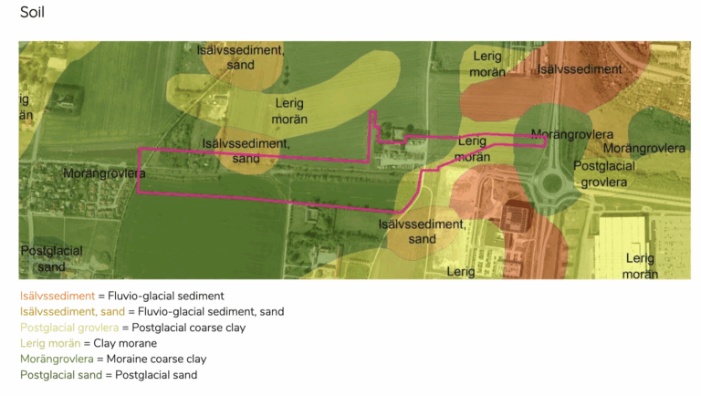
The area consists of a plain, which slopes slightly towards the Öresund Strait. The bedrock consists of limestone, and the soil is clay moraine in the farthest east and coarse moraine clay in the rest. The whole site is on the more nutritious part of the Ellenberg scale.
Hyllie Nature Axis will be a huge improvement to educational, recreational, biodiversity and cultural heritage values when finished. Malmö Stad writes, “The planned nature axis is intended to fulfil many purposes: promote biological diversity, provide the area with visual and recreational values and manage the area’s stormwater” which is something to aim towards in this project too.
The avenues in the area will be kept as they are. They contributed to a larger diversity and a higher ecological value, especially the old avenues, which could provide shelter for a high diversity of insects, and the mixed avenues with trees and shrubs, which could provide both food and shelter for different birds and insects.
The Hyllie Nature Axis will have different target groups. The people living nearby, who want to take their everyday walk, children who have their preschools around or elsewhere that are there for a school day trip and elderly people living nearby who want to be close to nature.
DESIGN PROPOSAL
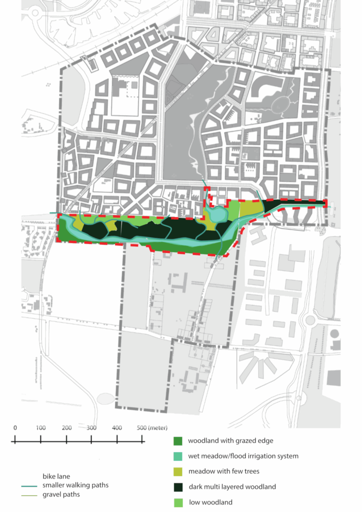
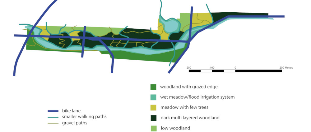
As you experience the concept of Nature in the City in Hyllie Naturaxel, the paths will take you through the different biotopes of the site.
The bike lane (blue) pawed and takes a similar route as it currently does today.
The smaller walking paths (turquoise) will consist of wooden walkways to make it easy for all people to navigate through the site, while also preventing disturbance to biodiversity and ecosystems from trampling.
The gravel path (green) will consist of bark chips, making it easier to take shorter loops when moving through the site.
project plan
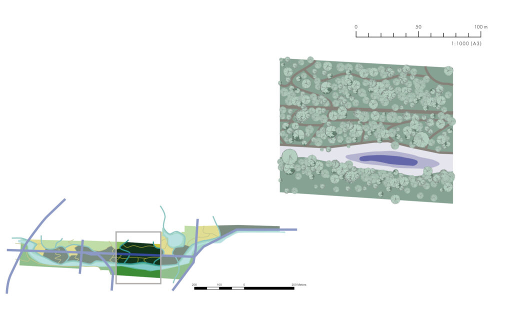
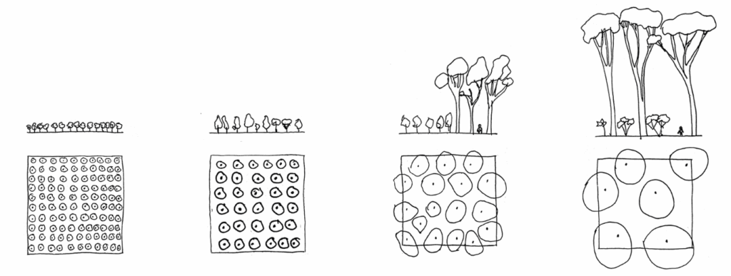
The design area consists of five biotopes.
The dark, multilayered woodland – A broadleaf forest
The meadow – A meadow with clusters of trees
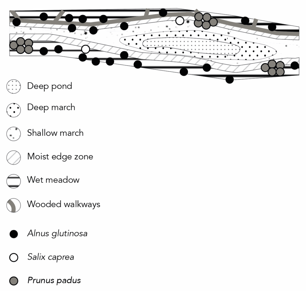
The wet meadow/flood irrigation system – A wet meadow with clusters of trees and shrubs, and a creek
The low woodland – A coppiced oak forest
The woodland with a grazed edge – A natural-looking woodland
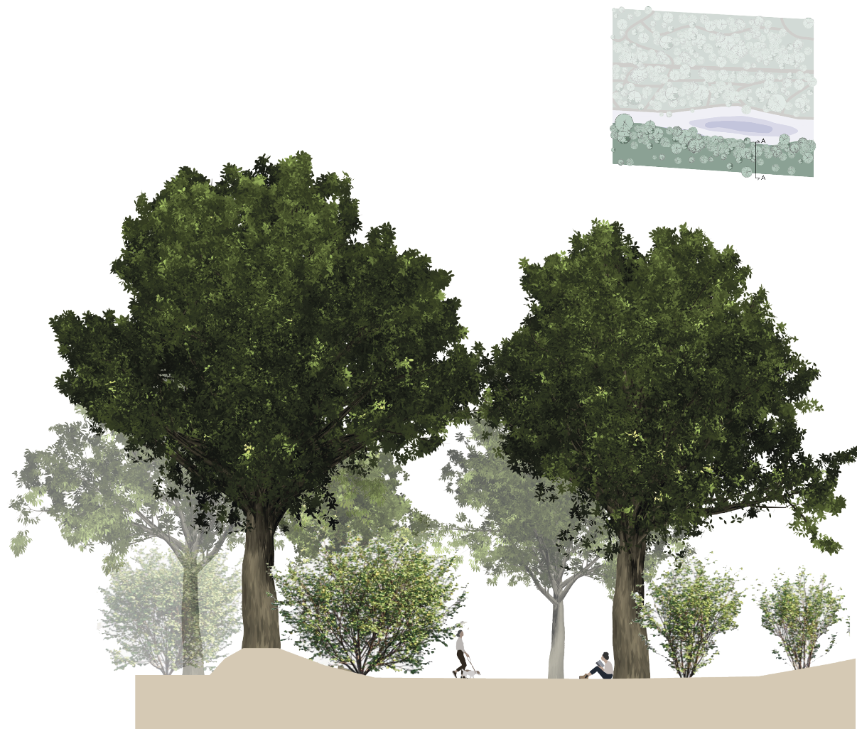
The chosen biotopes for this will be the wet meadow and the woodland with a grazed edge, both of which are located right next to the water, providing interesting transition zones and microhabitats.
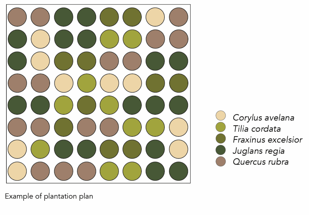
The dark, multilayered woodland
section A-A
Year 1-2
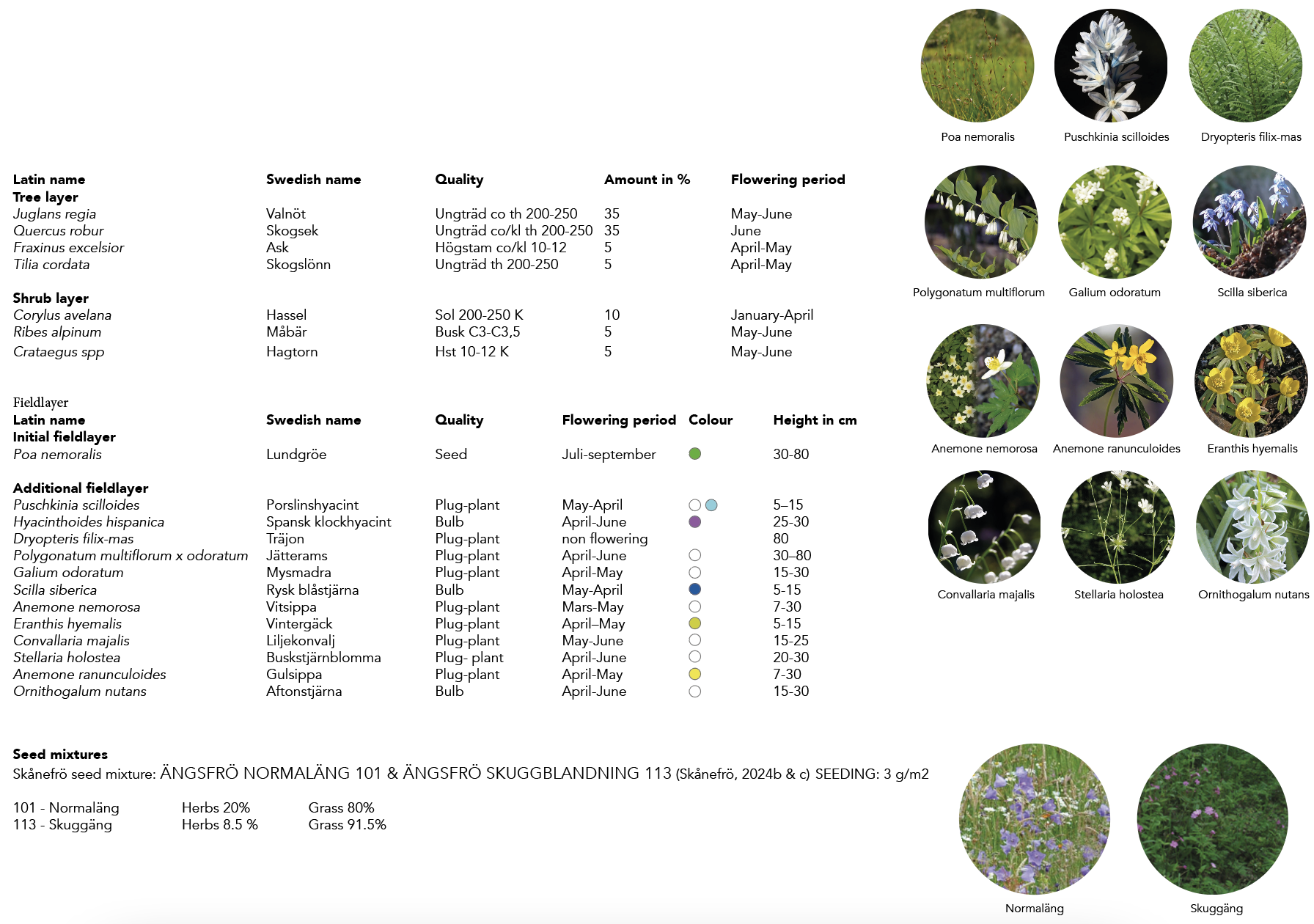
To create a diverse landscape, plant Quercus rubra and Juglans regia in rows 1.5 meters apart, with each plant spaced 1.5 meters apart. Alternate these species randomly, limiting consecutive plants of the same species to four. Intersperse Fraxinus excelsior or Tilia cordata every fifth tree, and Corylus, Crataegus spp, and Ribes alpinum every seventh plant. Mechanical weeding is advised for the first two seasons, followed by seeding Poa nemoralis and planting bulbs in the second autumn. Mix bulbs of Hyacinthoides hispanica, Scilla siberica, and Ornithogalum nutans at 50 bulbs per 10m².
Year 6-8
The first thinning, and should be concentrated to suppress species or Fraxinus excelsior, to minimize risk for spreading diseases as well as providing sufficient space for more dominant trees and shrubs. To reach the goal of dense woodland in the furthest north, towards a semi-open woodland structure, starting 50 meters from the wetland border, more harsh thinning will be done in this area.
Year 10-15
The second thinning should defuse the rows. After year 12-15, in March-April, the field layer can be introduced and established. Seed mix (1/3) to be infused with sawdust (2/3) and distributed by hand for a more random spread of the flora, the area should be ranked as to cover the seeds and watered. During this time plug-plants are also introduced, they are placed two to three of the same species in areas where Poa nemoralis have emigrated (left open spots).
Year 25
Onwards, additional thinning should occur with damages or sick vegetation. The field layer, trees and shrubs will be kept free growing with and dead wood should be kept on site.
Species selection
The goal is to create a balance between more light-demanding species in the upper layer and the shade-tolerant species in the lower layers. To achieve a multistoried stand, the number of crown-layer tree species is relatively low.
Soil preparation
Initial soil preparation entails deep ploughing to bring nutrients to the surface and bury any residual vegetation. Subsequent steps involve milling the soil and smoothing the surface through harrowing to eliminate weeds.
Establishment
Canopy and shrub layer
In the northern area, trees and shrubs will be densely planted (1.3-2 meters apart) to serve as a windbreak. Conversely, the southern area will see random tree placement (2-3 meters apart) to encourage broader and deeper tree crowns, resulting in a slightly more open structure and a density gradient.
Fieldlayer
Initially shade-tolerant grass, Poa nemoralis, is sown. The fieldlayer of herbs should be introduced after 10 years in connection to the second thinning. Herbs should be introduced as plug plants in a scattered patch pattern. The planting of the herbs should be congregated along the paths, glades and entrances.
Maintenance
Canopy and shrub layer
To maintain the desired multilayered forest, regular thinning is recommended during the initial 20 years. Thinning intervals of 5, 10, 15, and 20 years are advised, focusing on selective removal near clearings, paths, and edges. Timber remnants will be retained post-thinning.
Fieldlayer
Allow the various species to adapt to the diverse conditions throughout the site and naturally distribute themselves to achieve a more organic expression.
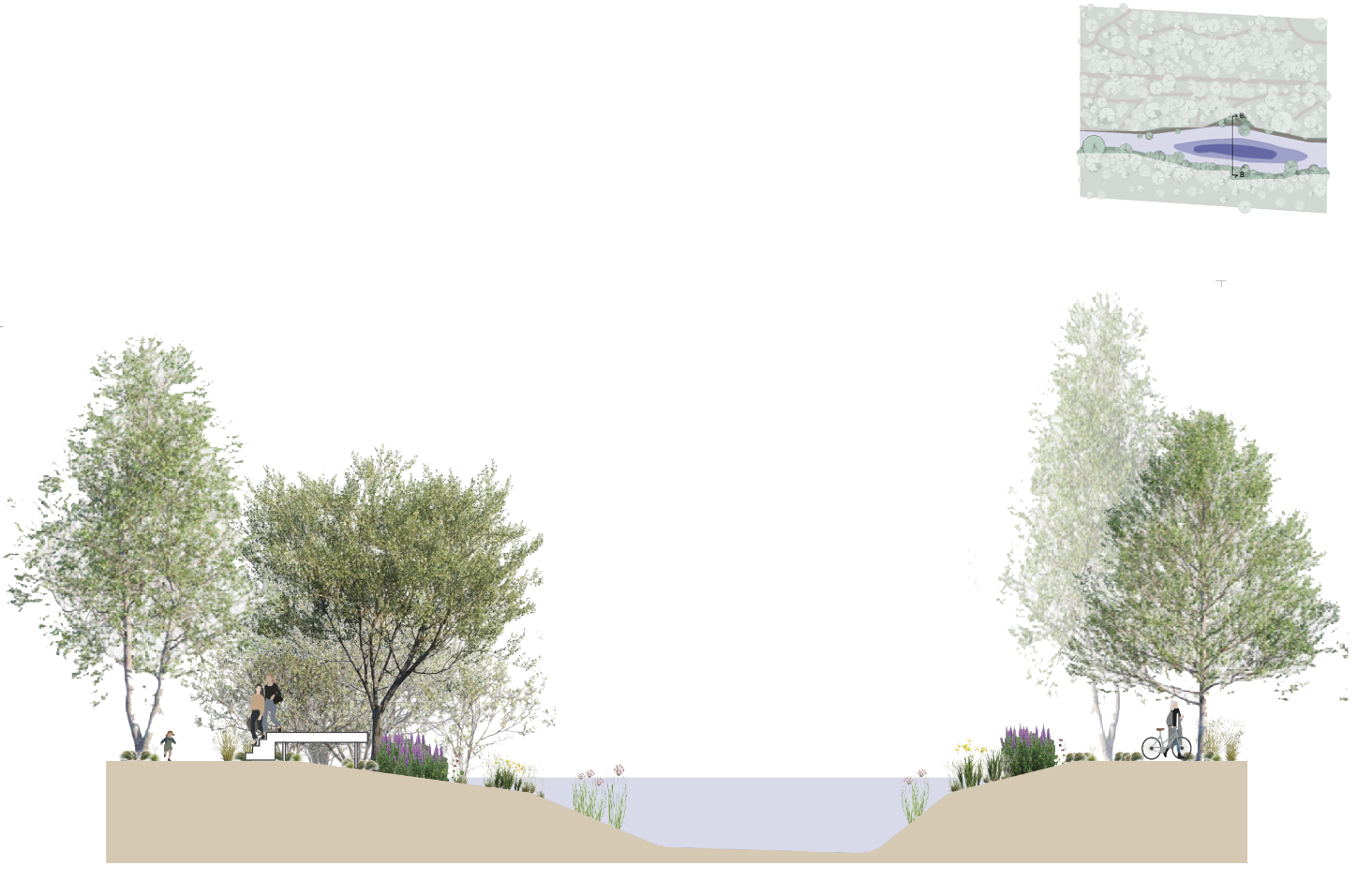
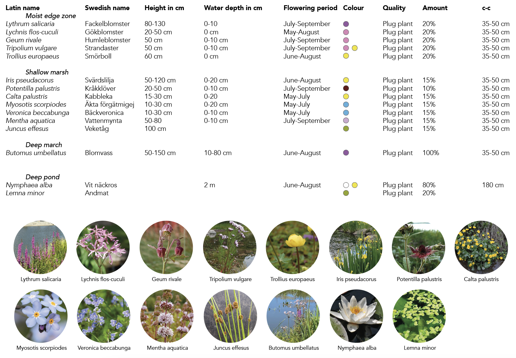
Wet meadow/flood irrigation system
section B-B
Selection of species
All selected species are tolerant of the moist and wet conditions of the biotope.
Soil preparation
The placement of the creek and pond is based on the location of the existing ditch. The topsoil is removed during the terrain modelling.
Establishment
The wet meadow is sown with a seed mixture adjusted to moist conditions. Trees are planted in a scattered pattern with varying distances according to the planting plan.
Maintenance
In the first two years, the meadow should be cut with a rotary mowing machine frequently, 3-5 times a year. When the meadow is established, it should be mowed twice every year. Once in late July, and additionally one time in early September. It shouldn’t be cut shorter than 5 cm, and the hay should be left lying for a few days to dry and shed seeds before it’s removed.
To slow down the natural succession of the pond, vegetation harvesting and the removal of sediments is required once a year. Heavy thinnings of trees in year 5, 10, 15 and 20 to achieve solitary trees with wide, deep crowns.
Have any questions? I am always open to talk about your business, new projects, creative opportunities and how I can help you.